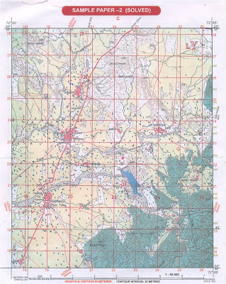
TOPOSHEET 1 FOR REVISION
TO ANSWER THESE QUESTIONS, CHECK THE TOPO 1 AND THE TOPOSHEET FROM YOUR WORK BOOK - APPENDIX 10 (PAGES 24-25)
a. In which quarter will you look for the lowest contour in the extract of the toposheet? Why should it be in this quarter?
b. Write down the highest and lowest spot heights found on this map. State whether they are in metres or feet.
c. Give a six figure grid reference for the peak of Bhuni-Margi Hill. Also state the grid number in which the hill is located.
d. In which compass direction does the village Pamera lie in respect of Gulabganj? How many kilometres is Pamera from Gulabganj?
e. What kind of roads connect i. Pamera with Gulabganj ii. Gulabganjwith Sirori, respectively?
f. State two important sources of irrigation water in this region. What inference do you draw from this about the main occupation of the people of this region?
g. On which bank of Sipu Nadi is Malgaon situated? What is the social significance of this village?
h. Write down the grid number of the region where you see considerable perennial water. What is the maximum height of the wall impounding water in the tank?

7 comments:
a ver good thing br it is helping me in learning toposheet br and plez update answers br
Dear Brother,
Many thanks for your blog. Its very useful. May I know what is the meaning of LY [red] in grid reference 2725? I find such alphabets, QC, QD etc in some other maps. What is the meaning of these?
Thank you,
Shyam, Geography Teacher,
Um, the letters are random. They indicate every 100 km of survey.
How to find the length of the map given
a question ftom icse 2009 paper
How to find the length of the map given
a question ftom icse 2009 paper
Sir from where should i check my answers?
How to find lowest n highest pointvon the map
Post a Comment