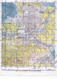
double click on the picture and then again click on it
a. What is meant by R. F. ? What is the R.F. of this Sheet?
R.F. means Representative Fraction.It is the ratio between the distances on the map to its corresponding distance on actual ground. The RF on this map is 1:50,000
b. What is a scale? What is the scale in this toposheet?
Scale is the ratio between the distance of any two points on the map and the actual distance of the same points on the ground.
The scale of the given map extract is 2 cm: 1 km or 1:50,000
c. Name the village where contour of 200 meteres crosses Varka Nala.
Odhava village
d. Give the four figure grid reference of the following:
i. settlement Bantawada - 9978
ii. Village Kotda - 8593
iii. The triangulated height of 277 metres - 8998
e. Name the village where contour of 200 metres crosses Varka Nala.
Odhava village
f. In which quarter of the map extract do you expect the lowest area to be? Why?
South-west quarter of the map is the lowest area because both rivers flow towards the south-west and spot heights are also decreasing in that direction.
g. In what two ways does the river bed of Sipu convey that it flows through a region of seasonal rainfall?
Sipu river flows through a region of seasonal rainfall because we can see an exposed broad sandy riverbed and a thin water channel. We can also see several cart tracks and pack tracks going through the river bed.
h. Give the six-figure grid reference of the following.
i. tringualted height 198 in village Jegol - 854905
ii. the confluence of Varka Nala with Sipu river. - 834927
iii. Survey tree near Gnangudra settlement. - 876934
iv. temple in Jkhapura -934767 or 935768 (approx)
i. What are the conventional signs near north east part of the sheet near open mixed jungle.
These are the broken ground.
j. Furnish two evidences to suggest that the village Jigol is rather better off than the other villages.
Village Jigol has many lined wells for irrigation purposes and several cart tracks.
k. Name any two methods by which relief can be shown on the map.
Relief can be shown on the map by contour lines and spot heights.
it was nice sir.its very nice to see u interested in this subject which hasnt seen any new inclusions for more than a decade now the same definitions and processes till now hope u continue the same overall it was very good!KEEP IT UP SIR!!!!!!!!!!
ReplyDeleteThanks for breaking down a complex topic into easy-to-understand points. The accuracy and speed of auto clicker enhance overall productivity, especially in high-volume tasks.
ReplyDelete