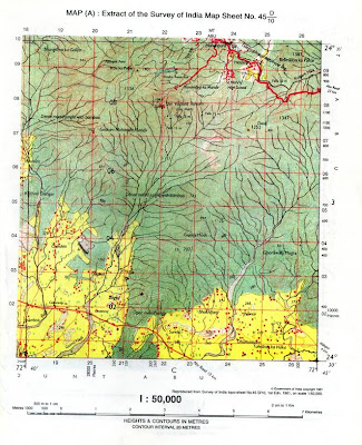
QUESTION:Study the extract of the Survey of India Map sheet No. 45 D/10 and answer the following questions:
a. Give the four figure grid reference for the:
i. Kodra Reservoir
ii. Ghorawala Magra
b. Mention two types of jungles seen in the map.
c. Define scale. What is the scale of the map extract provided to you?
d. What type of transportation system is available in this region? Support your answer with valid reason.
e. What is the chief occupation of the people living in this region? Give reason.
f. Name the main river draining this region shown in the map. What is the general direction of this river?
g. What is the area in square kilometers, of the forested region enclosed by Eastings 22 and 24 and Northings 04 and 06?
h. What is the drainage pattern in grid square 2303?
i. Where are the most of the permanent huts are located? Give reasons for their location.
j. What is the general direction of the Gomti Nadi in the southern half of the map extract? Give two reasons.

14 comments:
Did you practice?
it is an intresting toposheet...........i enjoyed while practicing it...........i liked it........
very niso br enjoyable and very useful
its very intresting and good...
i enjoyed thrughly...
its very helpful...and make us practice in easy manner..
it is really interesting. its making us to feel easy by practicing toposheets given in the blog.so i think its really beneficial.
BROTHER WHERE WILL I GET THE ANSWERS? I AM FROM DELHI AND NEEDS TO CONFIRM THE ANSWERS WRITTEN BY MYSELF FOR EXERCISE A5
hello Betty, thanks for using the blog. hope it is useful to you. send your email id to brhector21@gmail.com. i will send the answers to your email id.
98
25ma
23
How to find river,place,hills ect
Please help before 10 march
Hello Stanley, I saw your comment just now. I really didnt understand your question. When you see the contours, it means there are hills.Closer the contour lines, the steeper the hills are. I'm sure you will recognze the rivers in the toposheets. If you go through the blog properly, you will get all the clarifications.
Answer pl
Post a Comment