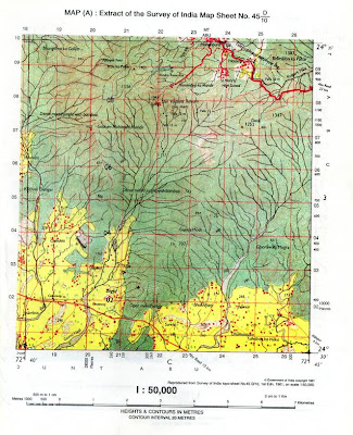
QUESTION:Study the extract of the Survey of India Map sheet No. 45 D/10 and answer the following questions:
a. Give the four figure grid reference for the:
i. Kodra Reservoir
ii. Ghorawala Magra
b. Mention two types of jungles seen in the map.
c. Define scale. What is the scale of the map extract provided to you?
d. What type of transportation system is available in this region? Support your answer with valid reason.
e. What is the chief occupation of the people living in this region? Give reason.
f. Name the main river draining this region shown in the map. What is the general direction of this river?
g. What is the area in square kilometers, of the forested region enclosed by Eastings 22 and 24 and Northings 04 and 06?
h. What is the drainage pattern in grid square 2303?
i. Where are the most of the permanent huts are located? Give reasons for their location.
j. What is the general direction of the Gomti Nadi in the southern half of the map extract? Give two reasons.
