

Friday, December 25, 2009
Sunday, December 20, 2009
Monday, December 14, 2009
Most of the lessons are not available anymore
Hi,
As I had said earlier, most of the lessons in geography are not available in the blog anymore. For example, the lessons on toposheets, maps, agriculture, physical features, location , climate, ..... are not availabe anymore. By the end of December, geoblog is not available for the viewers.The purpose of this blog was to interact with each other but I have not got expected response from the viewers. Thank you
Thursday, December 10, 2009
Map Work Questions
Dear Student,
Map work in ICSE exam carries 10 marks. So please locate the following places, rivers, ranges, areas of soil, minerals etc. Keep outline map of India with you.
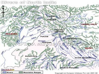
RIVERS:
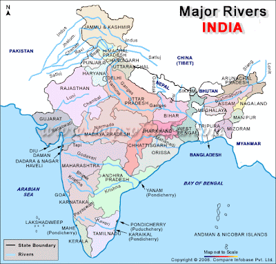
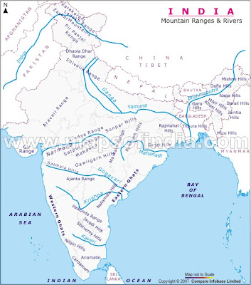
Map work in ICSE exam carries 10 marks. So please locate the following places, rivers, ranges, areas of soil, minerals etc. Keep outline map of India with you.
RIVERS:
- River Indus
- Rover Jhelum
- River Chenab
- River Ravi
- River Sutlej
- River Beas
The above rivers are part of River Indus system.
1. River Ganga
2.river Yamuna (tributary of Ganga)
3. River Chambal (tributary of Yamuna)
4. River Betwa (tributary of Yamuna)
5.River Son (tributary of Ganga)
6.River Damodar ( tributary of Ganga) (Chambal, Betwea, Son. Damodar rise at the ege of Peninsular Plateau and join Ganga on right bank
7. River Gomti
8.River Ghaghara
9.River Gandak
10. River Kosi --- all these tributaries of Ganga which join Ganga on left bank
1. River Brahamaputra
West Flowing Rivers
1. River Narmada
2. River Tapi
East Flowing rivers (in order from north to south)
1. River Mahanadi
2. River Godavari
3. River Krishna and its tributaries River Bhima and River Tungabhadra
4. River Kaveri
MOUNTAINS
(USE SECOND OUTLINE MAP )
1. Chagai Hills
2. Hindukush Mt
3. Karakoram Range
4. Aravalli Range
5. Sulaiman Mt
6. Kirthar Mt
7. Mt Godwin Austin (mark triangle )
8. Bolan Pass (use the symbol of pass)
9. Khyber Pass (use the symbol of pass)
10. Mt Everest (mark triangle)
11. Kanchanjunga (mark triangle)
12. Vindhyas
13. Satpura Mts
14. Maikala Range
15. Chota Nagpur Hills
16. Mahabaleshwar (use triangle)
17. Western Ghats
18. Palghat Pass
19. Annamalai Hills
20. Cardamom Hills
21. Nilgiri Hills
22. Eastern Ghats
23. Rajmahal Hills
24. Himalayas
25. Garo Hills (in Meghalaya)
26. Khasi Hills (in Meghalaya)
27. Jainthia Hills (in Meghalaya)
28. Shiwalik Hills
29. Chittagong Hills
PLATEAUS
Do you want to learn toposheets online?(Free service)
Hello,
Since many have asked me to explain toposheets thru gtalk. So if u want me to explain or teach the lesson through gtalk, plz mail to brhector21@gmail.com . Add me in your gtalk, so that when i'm online, u can ask questions. Do go through the blog once. I'm online from 6p.m. to 12 p.m and sometimes i'm online even in the morning. You can fix a time beforehand too. take care and enjoy geography.
With love and prayers,
Br Hector

Tuesday, December 8, 2009


Monday, December 7, 2009
10D3 MAP FOR PRACTICE-QUESTION 3
Hello Friends,
Only few days are left for the publication of this blog. So decided to upload few maps. I'm not expert in computers and so its an humble attempt to present the maps of South Asian nations. Hope you will benefit from it.
Double click on the image for the larger picture

10D2 MAP FOR PRACTICE - QUESTION 2
QUESTION 2
a. A region of North India receiving winter rainfall
b. Malabar Coast
c. Maikala Range
d. Suliaman range
e. Coramandal Coast
f. Patkai Bum
g. River Tungabhadra
h. Malwa Plateau
i. Coffee producing region of India
j. Kunlun Mts

10D8 MAPS FOR PRACTICE - QUESTION 1
MAP 1
A. RIVER KAVERI
B. NAMCHA BARWA
C. MARK AND NAME THE CAPITAL CITY OF PAKISTAN
D. DHAKA
E. SHADE AND LABEL THE KHASI HILLS
F. KATHIAWAR PENINSULA
G. GULF OF MANNAR
H. DIRECTION OF SUMMER MONSOON OVER SRI LANKA
I. A REGION OF RED SOIL
J. THE SUNDERBANS
DOUBLE CLICK ON THE IMAGE FOR LARGER PICTURE

Saturday, December 5, 2009
A6-IMPORTANT DEFINITIONS ON TOPOSHEETS
IMPORTANT DEFINITIONS
DEFINITIONS FROM TOPO MAPS
REPRESENTATIVE FRACTION (RF): It is the ratio between the distances on the map to its corresponding distance on actual ground. The RF on this map is 1:50,000.
2. SCALE : Scale is the ratio between the distance of any two points on the map and the actual distance of the same points on the ground.
The scale of the given map extract is 2 cm: 1 km or 1:50,000.
3. CONTOUR: Contours are imaginary lines drawn on maps, joining all places with the same height above sea level.
4. CONTOUR INTERVAL: The interval between two consecutive contours is called contour interval (*it is a constant 20 mts in your toposheets.)
5. INDEX CONTOUR: Contour lines are thickened at regular intervals to make it easier to read contours. For example at every 100 mts the contour line is made darker. The darker lines are called Index Contours.
6. TRIANGULATED HEIGHT: It is the height of a place which has been calculated using trigonometry, represented by a small triangle e.g. - 540
7. SPOT HEIGHT: The height of random places between contours shown with a dot. Eg - .425
8. BENCH MARK - Height of a place actually marked on a stone pillar, rock or shown on a building as a permanent reference. It is written as BM 200 m.
9. RELATIVE HEIGHT: Relative height is the height of a feature with reference to the height of the surrounding land and NOT to sea level.
It is represented by the height with a small ‘r’ eg –12r.
10. ROCK OUTCROP: It is a portion of rock jutting above the surface of the earth.
11. SHEET ROCK: Large areas of rock where the overlying soil layers have been eroded and removed due to mechanical weathering.
9 STONY WASTE : A large area usually in arid/semi arid regions where the finer sand/soil has blown away leaving a surface covered with boulders, stones and pebbles.
10. BROKEN GROUND: A relief feature found mostly in dry regions around rivers and streams. It is land around river, which is totally
weathered (exfoliated) due to alternate cooling and heating.
11. FIRELINE: A cleared pathway in a forest to prevent the spread of forest fires.
12. MIXED FOREST: A forest with more than two varieties of trees growing in close proximity to each other.
13. OPEN JUNGLE: A forest where trees are widely scattered.
14. DENSE JUNGLE. : A forest where trees grow very close to each other.
15. OPEN SCRUB: Scrub is a vegetation found in regions with less than
100 cms of rainfall. Therefore it indicates a dry region.
16. BRACKISH: It is a well, which has water with very high salt content – generally unfit for drinking purposes.
17. CAUSEWAY: It is a raised road over a small water body. (Usually a road used only in the non rainy months.}
18. CUTTING: A portion of land, which has been cut in order to make land available for transport routes. (it is indicative of a rocky region)
19. EMBANKMENT: They are raised rock or soil filled constructions on which roads/railway tracks are built. Also made near tanks and rivers to prevent flooding.
20. FORM LINES: Form lines are contour lines, but show only approximate heights above sea level as they are used to indicate the elevations of the area which are not accessible for proper survey. Hence they are drawn as broken lines and are called 'form lines'.
21. Q.C. Q.D., OC, OD,PQ, ETC / NATIONAL GRID REFERENCE/: These are alphabetical codes used in the survey map as their subdivisions which represent the biggest grid sq. of 10,000 square kms.
The Govt of India has adopted metric system for all measurements. All the ordnance survey maps issued by the Survey of India were drawn to the scale 2 cm = 1 km. In this system , the surveyed territory is divided into 100km X 100 km squares, and each square is denoted by English alphabets. for example, OC, OD, PQ, PG, etc . This system of map drawing is known as National Grid Reference.
22. LAYER TINTING: (colouring)
While spot heights show the height of the land, they only do so at certain points. To provide an overall image which conveyed height, a technique called layer tinting was developed. Layer tinting uses different colours (or shades) to represent different heights. It is a mapping convention for darker colours to signify greater height. When using layer tinting, green is often used for low land, yellow for higher land and brown for the highest land.
Layer tinting is most commonly found on physical maps. While layer tinting is useful, it does not show the detailed shape of the land.
23. DEPRESSION: It is a depression often found in sandy areas where the wind, having blown away the sand, leaves a hollow or a depression.
24. HACHURING: Early cartographers attempted to show surface features on maps by using the technique of hachuring. Hachures use short lines of varying thickness to show the shape and slope of the land. In accordance with this technique, the steeper the slope is, the thicker the lines are which represent it. While hachuring was initially innovative for its time, it gradually began to be replaced since the actual height of the land was not depicted.
25. LIME KILN OR BRICK KILN: These are open furnaces where limestone is purified or bricks are baked for construction purpose.
26. HILL SHADING: Hill shading resembles a light and shadow effect. Valleys and the sides of mountains appear as though they are cast in shadow. This is a visually striking method, which is ideal for providing an overall view of the relief of an area. Hill shading, however, does not show height which means that it is no more accurate than hachuring.
28. CUTTING: A cutting is an open vertical cut in high ground so that a road or a railway track can pass through.
29. MOUNDS: Mounds are small hills, just a few metres high. They are usually rounded on the top and covered with green vegetations. Sand hills in the desert and rock outcrops in stone areas can also be termed as mounds.
30. SYMBOL OF TELEGRAPH LINE: A telegraph line is indicated by bold and lite dots with the word telegraph or telephone written on it.
UNDERSTAND SOME OF THESE TERMS
27. NATIONAL GRID REFERENCE: The Govt of India has adopted metric system for all measurements. All the ordnance survey maps issued by the Survey of India are drawn to the scale 2 cm = 1 km. In this system , the surveyed terrirory is divided into 100 km x 100 km squares, and each square is denoted by Enlish lettersLEARN THEM BY HEART - ALL THE BEST !!!
Tuesday, November 24, 2009
ANSWERS FOR THE TOPOSHEET TEST

double click on the picture and then again click on it
a. What is meant by R. F. ? What is the R.F. of this Sheet?
R.F. means Representative Fraction.It is the ratio between the distances on the map to its corresponding distance on actual ground. The RF on this map is 1:50,000
b. What is a scale? What is the scale in this toposheet?
Scale is the ratio between the distance of any two points on the map and the actual distance of the same points on the ground.
The scale of the given map extract is 2 cm: 1 km or 1:50,000
c. Name the village where contour of 200 meteres crosses Varka Nala.
Odhava village
d. Give the four figure grid reference of the following:
i. settlement Bantawada - 9978
ii. Village Kotda - 8593
iii. The triangulated height of 277 metres - 8998
e. Name the village where contour of 200 metres crosses Varka Nala.
Odhava village
f. In which quarter of the map extract do you expect the lowest area to be? Why?
South-west quarter of the map is the lowest area because both rivers flow towards the south-west and spot heights are also decreasing in that direction.
g. In what two ways does the river bed of Sipu convey that it flows through a region of seasonal rainfall?
Sipu river flows through a region of seasonal rainfall because we can see an exposed broad sandy riverbed and a thin water channel. We can also see several cart tracks and pack tracks going through the river bed.
h. Give the six-figure grid reference of the following.
i. tringualted height 198 in village Jegol - 854905
ii. the confluence of Varka Nala with Sipu river. - 834927
iii. Survey tree near Gnangudra settlement. - 876934
iv. temple in Jkhapura -934767 or 935768 (approx)
i. What are the conventional signs near north east part of the sheet near open mixed jungle.
These are the broken ground.
j. Furnish two evidences to suggest that the village Jigol is rather better off than the other villages.
Village Jigol has many lined wells for irrigation purposes and several cart tracks.
k. Name any two methods by which relief can be shown on the map.
Relief can be shown on the map by contour lines and spot heights.
Monday, November 23, 2009

Thursday, November 19, 2009
Hello, If you are a regular visitor, plz write a comment
Hello,
Welcome to this blog! If you are a regular visitor of this blog, I request you to write suggestions and comments in this blog. You are also most welcome to become the follower of this blog so that I can update you about the blog regularly. Thank you. God bless. My other two blogs are:
www.brhectorsgeoworld.blogspot.com
www.brhectorsworld.blogspot.com
Saturday, November 7, 2009
ANSWERS FOR THE UNIT TEST-NOV 6
UNIT TEST
CLASS X
NOV 6
ANSWERS
1. Which is the largest mineral-based industry in India? Why is it called a key or basic industry?
The largest mineral-based industry in India is Iron and Steel Industry. It is called a basic or a key to other industries because many other industries depend on this.
2. Name four centres of this industry in the public sector concentrated in a single geographical region. With whose collaboration was each one of them set up?
Four centres of this industry in the public sector concentrated in a single geographical region are:
i. Bhilai Steel Plant (Russian Collaboration)
ii. Rourkela Plant (German Collaboration)
iii. Durgapur Plant (British Collaboration)
iv. Bokaro Plant (Russian collaboration)
3. Why is this industry concentrated in the Chhota Nagpur region? Which is the oldest and the privately owned plant?
This industry is concentrated in the Chhota Nagpur region, because of easy availability of its three basic raw materials- coal, iron ore, limestone, manganese. The oldest and the privately owned plant is the Jamshedpur Steel Plant.
4. Name four large-scale industries dependent on this industry? List two important products of petro-chemical industry.
The four large-scale industries dependent on this industry are:
i. Automobile industry – cars, trucks, tractors, buses, etc
ii. Shipbuilding Industry
iii. Machines, tools, light and Heavy engineering industry.
iv. Agricultural tools-tractors, combine harvesters, pumps, etc.
The products of petro-chemical industry are plastics, drugs, naphtha, petroleum, menthol, synthetic fibres, L.P.G. and kerosene.
Tuesday, November 3, 2009
D8-NATURAL VEGETATION AND ANIMAL LIFE
NATURAL VEGETATION AND ANIMAL LIFE
Natural vegetation and animal life depend on climate, relief and soil. The diversity of India’s climate and relief have made natural vegetation and animal life interdependent on each other and they form a single ecosystem. This ecosystem has evolved through thousands of years. Indiscriminate meddling with this ecosystem causes harmful effects. Natural vegetation and animal life are also called flora and fauna respectively.
NATURAL VEGETATION
India has a wide variety of natural vegetation ranging from tropical evergreen forests to desert vegetation. The natural vegetation of India can be divided into six main types. They are : -
1) Tropical evergreen forests,
2) Tropical deciduous forests or Monsoon forests,
3)Tropical thorn and shrub forests,
4) Desert vegetation,
5) Mangrove forests and
6)Himalayan vegetation.
1) Tropical evergreen forests: This type of vegetation is found in areas where rainfall is above 250 cms and temperature ranges between 250C and 270C. Since the trees are always green they are called evergreen forests. The heavy rainfall, high temperature and humidity are responsible for the growth of these dense forests. The trees grow about 60 mts. high. The branches of trees form a canopy and prevent the sun's rays from reaching the ground. In India, most of these forests are found on the western side of the Western Ghats,in the North-Eastern hills and the Andaman and Nicobar islands. The semievergreen forests are found in the lower rainfall areas of the Western Ghats, Orissa and West Bengal. Ebony, mahogany, rose-wood and rubber are the important trees. Bamboo bushes are also found.
2) Tropical deciduous forests: These forests are also called monsoon forests. They
cover a greater part of India. They are found in regions where the rainfall is between 75cms. and 250 cms. These forests are found on the eastern slopes of the Western Ghats, Jammu, West Bengal, Chhattisgarh, Orissa, Bihar and Jharkhand. In these forests, the trees are fewer and shorter. Bamboos and canes are also grown here. The trees shed their leaves at the beginning of summer. The important trees of these forests are teak, sal and sandal-wood. They have great commercial value. The deciduous forests of Karnataka have sandal-wood trees. Wherever these forests are cut down or burnt, bushes and grass have taken their place.
3) Tropical thorn and shrub forests: These forests are found in the central parts of the Deccan Plateau, southern parts of Maharashtra, Bellary of Karnataka, Cuddapha and Kurnool of Andhra Pradesh, where the annual rainfall is between 60 and 75 cms. These forests have short stemmed trees like Babul andKasavi trees and coarse grass. Palms and kikar trees are also found here.
4) Desert vegetation: This type of vegetation is found in regions where the annual
rainfall is less than 50 cms. Rajasthan's Thar desert, the borders of Punjab, Haryana and Gujarat have this type of vegitation. The trees, which grow here have deep roots, thick leaves and thorns. Date palms are common near oasis. Babul, palms, wild dates and cactus are the important trees. Babul tree yields gum and its bark yields tanning material.
5) Mangrove forests: These forests are formed due to tides. They are found along the deltas and estuaries of rivers that are subjected to tides. Pendent roots (like those of Banyan tree) are the characteristics of mangrove forests. The deltas of rivers Ganges, Godavari, Mahanadi and Krishna have these forests. In the Ganges delta, there are plenty of Sundari trees and the forests are known as ‘Sunderbans’. These trees are used for making furniture and boats. These forests also yield firewood and tanning material. Canes, palms and "Kendale" trees are also found here.
6) Himalayan or Alpine vegetation: Different types of vegetation are found in the
Himalayan mountains. The vegetation changes with altitude and rainfall. The lower regions of the Himalayas have tropical evergreen forests upto 1,500 mts. Teak, sal and rose-wood are the important trees. Temperate forests are found between 1,500 to 3,650 mts. They are also called coniferous forests. The important trees of this vegetation are silver fir, oak, spruce, laurels, chestnut etc. Grasslands are found in altitude between 3,650 to 4,875 mts. Rhododendron, willow, juniper and primrose trees are found here. Flowering plants are found in Alpine meadows. During summer, at still higher altitude lichen and moss are found. Above 6,000 mts. the region is covered with snow and hence no vegetation is found.
IMPORTANCE OF FORESTS: Forests are a very important natural resource. They
provide raw materials to industries such as timber, bamboo, cane, gum, medicinal
plants, shrubs etc. They provide fodder to cattle. In addition to these benefits, there are other advantages which are of great importance. They are as follows:
1) Forests provide moisture and lower the temperature,
2) They prevent soil erosion and preserve the fertility of the soil,
3) Forests provide home for many animals and birds, thus preserving bio-diversity,
4) Forests help to preserve the ecological balance.
Forests are depleted due to large-scale cutting of trees due to industrial development, cultivation of crops, over-grazing by cattle, construction of railways and roadways, irrigation and power projects. This depletion of forests has resulted in floods and soil erosion. Due to increase in population, demand for forest products has increased. So, there is great need to protect forests. By planting more and more trees, we have to conserve forests.
CONSERVATION OF FORESTS: Forests are a natural gift to humankind. Human
beings first lived in forests. Destruction of forests results in soil erosion, floods, drought etc. Hence, realising the importance of forests, the Central Government has formed a national forest policy in 1952. It has a threefold plan namely:
1) Nationalisation of forest operations
2) Protection and operation of wild life and environment and social forestry
3) Commercialisation of industrial forest operation
Social forestry aims at not only providing enough firewood, fodder and other forest products but also to meet the requirements of ecological balance through large scale afforestation in community land and waste land. “Vanamohotsava” which was started in 1950, aims at planting thousands of seedlings during July and August. Thus it helps to preserve ecological balance.
WILD LIFE
India has a variety of wild life because of its varied relief features such as climate
and natural vegetation. There are about 80,000 species of wild animals, birds and
fishes. India has some rare animals which are not found in any other part of the world. eg. swamp deer, Chausinga (four-horn antelope), Kashmir stag, black buck and Neelgai. The spotted deer of India is very beautiful. Horned rhinoceros is found only in India and Nepal. Some of the carnivores animals such as lions, tigers and leopards are found in our forests. The Gir forests of Saurashtra is the natural habitat of lions. The famous Bengal tiger is found in the Sunderbans. The national animal of India is the Tiger. The Himalayas are the home of several interesting animals, like the wild sheep, yak, the mountain goats, the ibex, the shrew, the tapu, the panda and the snow leopard. Of the many species of monkeys, the languar is the most common.
India has a vaiety of bird life. The falcon (hawk), geese, mynahs, parrots, pigeons,
cranes, hornbills, sunbirds and kingfishers are found in forests and marshy lands. The Peacock is our national bird. Special efforts are made to protect the endangered species of wild life. National Parks and Wild Life Sanctuaries have been opened in order to preserve wild life. There are 73 national parks, 447 wild life sanctuaries and 17 tiger reserves. The Bandipur, Nagarahole and Bannerghatta National Parks are in Karnataka. These areas have become places of tourist interest.
Friday, October 2, 2009
www.brhectorshistoryworld.blogspot.com
The following lesssons are available in www.brhectorshistoryworld.blogspot.com
1. INDUS VALLEY CIVILIZATION
http://brhectorshistoryworld.blogspot.com/search/label/INDUS
2. FIRST WAR OF INDIAN INDEPENDENCE
http://brhectorshistoryworld.blogspot.com/search/label/WAR%20OF%20INDIAN%20INDEPENDENCE
3.FIRST WORLD WAR
http://brhectorshistoryworld.blogspot.com/search/label/WORLD%20WAR%20I
4. SECOND WORLD WAR
http://brhectorshistoryworld.blogspot.com/search/label/SECOND%20WORLD%20WAR
5. UNITED NATIONS
http://brhectorshistoryworld.blogspot.com/search/label/UNITED%20NATIONS%20ORGANISATIONS
Tuesday, September 22, 2009
CLASS X MID TERM EXAM
DON BOSCO ICSE SCHOOL
TIME: 2 HRS CLASS X TOTAL MARKS: 80
i) Answer to this paper must be written on the paper provided separately.
ii) You will not be allowed to write during the first 15 minutes, this time has to be spent reading the question paper.
iii) The time given at the head of the paper is the time allowed for writing the answers.
iv) Attempt all questions from Part I (compulsory). A total of five questions have to be attempted from Part II.
v) The intended marks for the questions or parts of questions are given in brackets [ ] .
************************************************************************
PART-1 [30 MARKS]
[Answer all the questions]
QUESTION 1 [2X10=20]
Study the Survey of India Map Sheet No.45D/7 (Es 80-89 and Ns 76-86) and answer the following questions. (appendix 13)
a. Give the six figure grid reference of a ∆168 and a four figure grid of settlement Nilpur.
b. Give the meaning of the following conventional signs:
i. The bluespot in village Kheda in the south-west corner of the map.
ii. The irregular black lines along the Sarod Nala in the square whose four figure grid reference
is 8284.
c. State two advantages that Dantiwada (South of River Banas) has over other settlements in the region?
d. What does 6r written against the unmetalled road in grid square 8478 mean?.
e. What is the direction of the Rriver Banas and on which bank of the river is village Nadotra (Brahmanivas) located.?
f. What does “Dep” mean in the grid square 8777?
g. What is the general pattern of human settlement in the map extract?
h. What is the area in square kms of the cultivated region enclosed by vertical grid lines 82 and 84 and the horizontal grild lines 78 and 80?
i. In the south-east part of the map, why do some of the streams do not join the main river?
j. What is the length of the canal under construction in kms?
QUESTION 2 [10x1=10]
On the outline of map provided, mark and name:
a. The Capital of Nepal
b. The Rann of Kutch
c.The Eastern Coastal Plains
d. Maysweniram
e. The State which produces most cotton in India
f. The River Satluj
g The Gulf of Manner
h.The Satpura Mountain Range
i. The Malwa Plateau.
j. A region of black soil in India.
PART II (50marks)
QUESTION 3 [2+2+3+3=10]
a. What is a land locked country? Name two landlocked SAARC countries.
b. What are Tarai? Where exactly are they located?
c. Distinguish between an East-flowing and a West-flowing river.
d. Which are the States in India that receive winter rain? How is this rain economically beneficial?
QUESTION 4 [2+2+3+3=10]
a. What are the main factors that determine the development of industries in a region?
b. Name a plantation crop. Mention two characteristics of plantation farming with reference to this crop.
c. Which are the two staple crops of India? Mention the agricultural season in which each they are grown.
d. Which is the most densely populated country of South Asia? Give two reasons for this.
QUESTION 5 [2+2+1+2+3=10]
a. What are fossil fuels? Why are they useful?
b. Mention why sugar production is low in India?
c. Study the table given below and answer the questions given below.
Station Month J F M A M J J A S O N D
A Temp.
In °C 12.7 15.1 22.1 31.8 37.2 39.1 37.3 33.4 28 26.7 16.1 13.6
Rainfall
In cms 2.1 2.3 1.0 0.9 1.5 5.6 18.3 18.9 15.1 0.6 0.3 1.8
B Temp.
In °C 23.1 24.8 26.5 29.3 32 32.8 33.1 32.1 30.5 29.3 28.7 26.1
Rainfall
In cms 15.3 10.1 0.3 0.1 1.3 4.5 6.1 10.2 10.5 20.1 16.8 19.0
1. Calculate the annual rainfall in station A (1)
2. What is the annual range of temperature in station B? (2)
3. Name the winds that bring most of the rainfall to station B. State one reason for your answer.
d. Explain the mechanism of the direction of the Bay of Bengal branch of the South-West monsoon. (3)
QUESTION 6 [2+2+3+3=10]
a. Why does the Indian economy depend on the monsoon? Give two points.
b. When is wheat harvested? Name two States that lead in wheat production.
c. Why is the Japanese method of planting rice considered to be the best?
d. Where do you find red soil in India? What are its disadvantages?
QUESTION 7 [2+2+3+3=10]
a. What does soil formation depend on?
b. How is man responsible for soil erosion?
c. Which is the most expensive soil in India? How has it been formed? State one
characteristic feature of this soil.
d. Mention any two important aspects of hydro-electrical power in South India.
QUESTION 8 [2+2+3+3=10]
a. Why is petroleum an important source of energy?
b. How can the desert be protected from erosion?
c. Where is desert soil found in India? Mention its characteristics.
d. Which are the two States in India that lead in iron-ore production? What is its main use?
QUESTION 9 [2+2+3+3=10]
a. Why is South Asia considered a region of great physical diversity? Give two examples.
b. In reference to the Malwa Plateau:
(i) Where is it located?
(ii) Name the rivers that drain it.
(iii) What is it made up of?
c. Describe briefly the climatic conditions required for the cultivation of rubber.
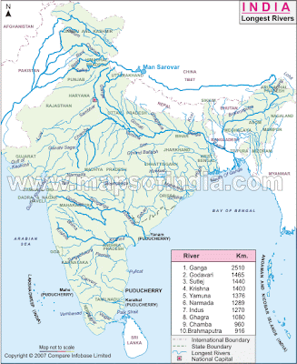
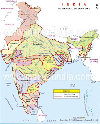
d. Into how many drainage systems can the rivers of Peninsular India be grouped? Which is the longest river here and where does it originate?
QUESTION 10 [2+2+3+3=10]
(a) Mention two differences between the cyclonic rain in Bangladesh and the cyclonic rain in Pakistan.
(b) Why is Pakistan often described as the 'Gift of the Indus'? Give two reasons.
(c) Mention three differences between the Western Ghats and the Eastern Ghats.
(d) Give three reasons why Bangladesh is one of the most densely populated countries in the world.
QUESTION 11 [2+2+3+3=10]
a. What is the latitudinal and longitudinal extent of Pakistan?
b. Name the hills that make up the Purvanchal Ranges in India.
c. Mention three benefits of the long coastline of India.
d. Give reasons for the following:
(i) The Deccan plateau is a highly dissected one.
(ii) Most of the rivers in South India flow into the Bay of Bengal.
(iii) The Rann of Kutch is not cultivated.
*********************************************************************
ANSWERS
DON BOSCO ICSE SCHOOL
TIME: 2 HRS CLASS X TOTAL MARKS: 80
i) Answer to this paper must be written on the paper provided separately.
ii) You will not be allowed to write during the first 15 minutes, this time has to be spent reading the question paper.
iii) The time given at the head of the paper is the time allowed for writing the answers.
iv) Attempt all questions from Part I (compulsory). A total of five questions have to be attempted from Part II.
v) The intended marks for the questions or parts of questions are given in brackets [ ] .
************************************************************************
PART-1 [30 MARKS]
[Answer all the questions]
QUESTION 1 [2X10=20]
Study the Survey of India Map Sheet No.45D/7 (Es 80-89 and Ns 76-86) and answer the following questions. (appendix 13)
a. Give the six figure grid reference of a ∆168 and a four figure grid of settlement Nilpur.
b. Give the meaning of the following conventional signs:
i. The bluespot in village Kheda in the south-west corner of the map.
Perennial lined wells
ii. The irregular black lines along the Sarod Nala in the square whose four figure grid reference is 8284.
ii. The irregular black lines along the Sarod Nala in the square whose four figure grid reference is 8284.
Broken ground
c. State two advantages that Dantiwada (South of River Banas) has over other settlements in the region?
Post office and Inspection Bungalow
d. What does 6r written against the unmetalled road in grid square 8478 mean?.
It is the relative height or steepness of the road which is 6 metres.
e. What is the direction of the River Banas and on which bank of the river is village Nadotra (Brahmanivas) located.?
The general direction of the river is east to west. Village Nadotra (Brahmanivas) is located on the right bank of the river.
f. What does “Dep” mean in the grid square 8777?
It means Depression. Depression is generally written on the map in a dry area where the wind has carried away the soil and leaving behind a hollow.
g. What is the general pattern of human settlement in the map extract?
Dispersed.
h. What is the area in square kms of the cultivated region enclosed by vertical grid lines 82 and 84 and the horizontal grid lines 78 and 80?
On the given map each grid square measures 2 cm X 2cm or 1 km X 1km
Therefore the area of each square is 1 sq km.
The number of squares between Eastings 82 and 84 and Northings 78 and 80 is 4.
Therefore the total area is 4 square kms.
i. In the south-east part of the map, why do some of the streams do not join the main river?
In the sandy areas, the streams have disappeared either due to sandy soil or high rate of evaporation.
j. What is the length of the canal under construction in kms?
2 cms on the map represents 1 km on the ground.
The length of the canal on the map is 4 cms.
Therefore 4 cms on the map represents 2 kms on the ground. So the length of the canal under construction is 2 kms.
QUESTION 2 [10x1=10]
On the outline of map provided, mark and name:
a. The Capital of Nepal
b. The Rann of Kutch
c.The Eastern Coastal Plains
d. Maysweniram
e. The State which produces most cotton in India
f. The River Satluj
g The Gulf of Manner
h.The Satpura Mountain Range
i. The Malwa Plateau.
j. A region of black soil in India.
PART II (50marks)
QUESTION 3 [2+2+3+3=10]
a. What is a land locked country? Name two landlocked SAARC countries.
A LANDLOCKED COUNTRY IS COMMONLY DEFINED AS ONE ENCLOSED OR NEARLY ENCLOSED BY LAND. BHUTAN AND NEPAL.
b. What are Tarai? Where exactly are they located?
THE WORD TARAI, A TERM PRESUMED TO BE DERIVED FROM PERSIAN, MEANS "DAMP," AND IT APPROPRIATELY DESCRIBES THE REGION'S HUMID AND HOT CLIMATE. THE REGION WAS FORMED AND IS FED BY MAJOR RIVERS.
c. Distinguish between an East-flowing and a West-flowing river.
1. EAST FLOWING
THE MAIN EAST FLOWING RIVER SYSTEMS ARE THE GANGES RIVER, THE INDUS AND THE BRAHMAPUTRA RIVER SYSTEMS.
THE EAST FLOWING RIVERS FORM LARGE BASINS. MANY RIVERS PASS THROUGH THE HIMALAYAS. THESE DEEP VALLEYS WITH STEEP ROCK SIDES WERE FORMED BY THE DOWN - CUTTING OF THE RIVER DURING THE PERIOD OF THE HIMALAYAN UPLIFT. THEY PERFORM INTENSE EROSIONAL ACTIVITY UP THE STREAMS AND CARRY HUGE LOAD OF SAND AND SILT. IN THE PLAINS, THEY FORM LARGE MEANDERS, AND A VARIETY OF DEPOSITIONAL FEATURES LIKE FLOOD PLAINS, RIVER CLIFFS AND LEVEES.THESE RIVERS ARE PERENNIAL AS THEY GET WATER FROM THE RAINFALL AS WELL AS THE MELTING OF ICE. NEARLY ALL OF THEM CREATE HUGE PLAINS AND ARE NAVIGABLE OVER LONG DISTANCES OF THEIR COURSE. THESE RIVERS ARE ALSO HARNESSED IN THEIR UPSTREAM CATCHMENT AREA TO GENERATE HYDROELECTRICITY.
2. WEST FLOWING RIVER
THE MAIN WEST FLOWING RIVER SYSTEMS INCLUDE THE NARMADA, THE TAPI, THE GODAVARI, THE KRISHNA, THE KAVERI AND THE MAHANADI RIVER SYSTEMS.
THE WEST FLOWING RIVERS FLOW THROUGH SHALLOW VALLEYS. A LARGE NUMBER OF THEM ARE SEASONAL AS THEIR FLOW IS DEPENDENT ON RAINFALL. THE INTENSITY OF EROSIONAL ACTIVITIES IS ALSO COMPARATIVELY LOW BECAUSE OF THE GENTLER SLOPE. THE HARD ROCK BED AND LACK OF SILT AND SAND DOES NOT ALLOW ANY SIGNIFICANT MEANDERING. MANY RIVERS THEREFORE HAVE STRAIGHT AND LINEAR COURSES. THESE RIVERS PROVIDE HUGE OPPORTUNITIES FOR HYDRO-ELECTRIC POWER.
d. Which are the States in India that receive winter rain? How is this rain economically beneficial?
TAMIL NADU COAST. ABOUT 60-70% OF THE RAINFALL OCCURS DURING THIS TIME. IMPORTANT FOR RABI CROPS, RECHARGE OF NON PERINIAL RIVERS ETC.
QUESTION 4 [2+2+3+3=10]
a. What are the main factors that determine the development of industries in a region? (any two points)
Factors responsible for location of industry
• HUMAN FACTORS:-
• CAPITAL – Big cities like Mumbai, Kolkotta, Delhi, Chennai are big industrial centres because the big capitalists live in these cities.
• GOVERNMENT POLICIES:- Government activity in planning the future distribution of industries, for reducing regional disparities, elimination of pollution of air and water and for avoiding their heavy clustering in big cities, has also become an important locational factor.
• MARKET – The entire process of manufacturing is useless until the finished goods reach the market. Nearness to market is essential for quick disposal of manufactured goods. It helps in reducing the transport.
OTHER FACTORS
• Availability of raw materials
• Power resources,
• Transport and communication facilities
• Skilled and unskilled labour,
• Favourable climate
• Capital
• Water resources
• Market
• Government policy
b. Name a plantation crop. Mention two characteristics of plantation farming with reference to this crop.
Tea is a plantation crop.
Climatic Requirements: Temp - 13 degree C - 35 degree C,
Rainfall - 150 cms -250 cms
c. Which are the two staple crops of India? Mention the agricultural season in which each they are grown.
Rice and Wheat
Rice- Kharif
Wheat- Rabi
d. Which is the most densely populated country of South Asia? Give two reasons for this.
Bangladesh is one of most thickly populated small river delta. Very fertile land, easy to plough and grow food grain makes its population extremely reliant on agriculture for years.
d. Which is the most densely populated country of South Asia? Give two reasons for this.
Bangladesh is one of most thickly populated small river delta. Very fertile land, easy to plough and grow food grain makes its population extremely reliant on agriculture for years.
QUESTION 5 [2+2+1+2+3=10]
a. What are fossil fuels? Why are they useful?
b. Mention why sugar production is low in India?
c. Study the table given below and answer the questions given below.
Station
Month J F M A M J J A S O N D
A Temp.
In °C 12.7 15.1 22.1 31.8 37.2 39.1 37.3 33.4 28 26.7 16.1 13.6
Rainfall
In cms 2.1 2.3 1.0 0.9 1.5 5.6 18.3 18.9 15.1 0.6 0.3 1.8
B
Temp.
In °C 23.1 24.8 26.5 29.3 32 32.8 33.1 32.1 30.5 29.3 28.7 26.1
Rainfall
In cms 15.3 10.1 0.3 0.1 1.3 4.5 6.1 10.2 10.5 20.1 16.8 19.0
1. Calculate the annual rainfall in station A (1)
B
Temp.
In °C 23.1 24.8 26.5 29.3 32 32.8 33.1 32.1 30.5 29.3 28.7 26.1
Rainfall
In cms 15.3 10.1 0.3 0.1 1.3 4.5 6.1 10.2 10.5 20.1 16.8 19.0
1. Calculate the annual rainfall in station A (1)
2. What is the annual range of temperature in station B? (2)
3. Name the winds that bring most of the rainfall to station B. State one reason for your answer.
d. Explain the mechanism of the direction of the Bay of Bengal branch of the South-West monsoon. (3)
QUESTION 6 [2+2+3+3=10]
a. Why does the Indian economy depend on the monsoon? Give two points.
b. When is wheat harvested? Name two States that lead in wheat production.
c. Why is the Japanese method of planting rice considered to be the best?
d. Where do you find red soil in India? What are its disadvantages?
QUESTION 7 [2+2+3+3=10]
a. What does soil formation depend on? (any two)
ii) VEGETATION: The growth and decay of vegetation determines the humus content of the soil. Roots of plants penetrate the soil and make it porous.
iii. Bio-chemical processes taking place in the soil: Bacteria and fungi cause the decay of plants and animal remains. Some transform the atmospheric nitrogen into soil nitrogen.
iv. CLIMATE : Climate is the most important single factor in the soil formation. the amount of rainfall and range of temperature are the most important climatic factors affecting soil formation.
v. RELIEF: Low relief areas generally experience deposition and have deep layer of soil whereas the soils are generally shallow in the plateau areas.
vi) PARENT MATERIAL: Parent rock determines the composition of soil.
b. How is man responsible for soil erosion?
Soil erosion is the removal of soil by the forces of nature, particularly wind and water. Soil erosion mainly takes place due to man’s activities such as deforestation, overgrazing of cattle, faulty methods of cultivation.
c. Which is the most expensive soil in India? How has it been formed? State one
characteristic feature of this soil.
d. Mention any two important aspects of hydro-electrical power in South India.
QUESTION 8 [2+2+3+3=10]
a. Why is petroleum an important source of energy?
b. How can the desert be protected from erosion?
c. Where is desert soil found in India? Mention its characteristics.
Because of low water retention power and very low humus content, desert soils are unsuitable for
farming. However, under irrigation they can yield rich crops.
Rajasthan, North Gujarat and Southern Punjab
d. Which are the two States in India that lead in iron-ore production? What is its main use?
QUESTION 9 [2+2+3+3=10]
a. Why is South Asia considered a region of great physical diversity? Give two examples.
DUE TO THE PRESENCE OF THAR DESERT, DECCAN PLATEAU, HIMALAYAS, COASTAL PLAINS, RIVER PLAINS ETC.
b. In reference to the Malwa Plateau:
(i) Where is it located?
(ii) Name the rivers that drain it.
(iii) What is it made up of?
MALWA PLATEAU IS LOCATED BETWEEN THE ARAVALLIS AND THE VINDHYAS. THE ARAVALLIS LIE TO ITS WEST AND THE VINDHYAS LIE TO ITS SOUTH.
CHAMBAL, SIND AND BETWA ARE THE RIVERS THAT DRAIN IT.THEY WERE FORMED BY SOLIDIFIED MOLTEN LAVA. THE FLAT TOP IS FORESTED AND BROKEN BY RAVINES
CHAMBAL, SIND AND BETWA ARE THE RIVERS THAT DRAIN IT.THEY WERE FORMED BY SOLIDIFIED MOLTEN LAVA. THE FLAT TOP IS FORESTED AND BROKEN BY RAVINES
c. Describe briefly the climatic conditions required for the cultivation of rubber.
d. Into how many drainage systems can the rivers of Peninsular India be grouped? Which is the longest river here and where does it originate?
RIVERS OF PENINSULAR INDIA CAN BE GROUPED INTO EAST FLOWING TOWARDS BAY OF BENGAL AND WEST FLOWING TOWARDS ARABIAN, TOWARDS GANGA, I.E. FLOWING NORTH FROM THE VINDHYAS, GODAVARI, RISING IN THE WESTERN GHATS.
QUESTION 10 [2+2+3+3=10]
(a) Mention two differences between the cyclonic rain in Bangladesh and the cyclonic rain in Pakistan.
QUESTION 10 [2+2+3+3=10]
(a) Mention two differences between the cyclonic rain in Bangladesh and the cyclonic rain in Pakistan.
BANGLADESH:- OCCURS IN SUMMER, OCCURS BECAUSE OF TROPICAL CYCLONE.
PAKISTAN :- :- OCCURS IN WINTER, OCCURS BECAUSE OF WESTERN DISTURBANCES.
PAKISTAN :- :- OCCURS IN WINTER, OCCURS BECAUSE OF WESTERN DISTURBANCES.
(b) Why is Pakistan often described as the 'Gift of the Indus'? Give two reasons.
WITHOUT THE PRESENCE OF THIS RIVER PAKISTAN WOULD HAVE BEEN A DESERT REGION. THE LONGITUDINAL EXTENT OF THE RIVER PROVIDES LIVELIHOOD TO THE PEOPLE OF PAKISTAN.
(c) Mention three differences between the Western Ghats and the Eastern Ghats.
1. WESTERN GHATS :- IT RUNS PARRELL TO THE WEST COAST.AVERAGE ELEVATION IS 900-1100 MTS. IT IS A CONTINUOUS WALL.SOURCE OF THREE LARGEST PENINSULAR RIVERS. LIES ALMOST PERPENDICULAR TO SOUTH EAST MONSOON.
2. EASTERN GHATS :- IT RUNS PARRELL TO THE EAST COAST. AVERAGE ELEVATION IS 600 MTS. IT IS A BROKEN WALL.DISECTED BY PENINSULAR RIVERS. LIES ALMOST PARALLEL TO SOUTH EAST MONSOON ORIGINATING FROM BAY OF BENGAL.
2. EASTERN GHATS :- IT RUNS PARRELL TO THE EAST COAST. AVERAGE ELEVATION IS 600 MTS. IT IS A BROKEN WALL.DISECTED BY PENINSULAR RIVERS. LIES ALMOST PARALLEL TO SOUTH EAST MONSOON ORIGINATING FROM BAY OF BENGAL.
(d) Give three reasons why Bangladesh is one of the most densely populated countries in the world.
Bangladesh is one of most thickly populated small river delta. Very fertile land, easy to plough and grow food grain makes its population extremely reliant on agriculture for years.
QUESTION 11 [2+2+3+3=10]
a. What is the latitudinal and longitudinal extent of Pakistan?
24degree N TO 37degree N LATITUDE AND 61degreeE TO 75degreeE LONGITUDE
b. Name the hills that make up the Purvanchal Ranges in India.
GARO, KHASI, JAINTIA, LUSHAI,MIZO, NAGA AND MANIPUR
c. Mention three benefits of the long coastline of India.
HARBOURS
FERTILE PLAIN
EXPORT CENTERS
ABUNDANT MONAZITE DEPOSIT AND PETROLEUM
FERTILE PLAIN
EXPORT CENTERS
ABUNDANT MONAZITE DEPOSIT AND PETROLEUM
d. Give reasons for the following:
(i) The Deccan plateau is a highly dissected one.
THE PLATEAU IS DISSECTED BY MANY RIVERS. THE REGION ISHIGHLY ERODED WITH DEEP RAVINES SCARRING THE LANDSCAPE.
(ii) Most of the rivers in South India flow into the Bay of Bengal.
DUE TO THE SLOPE OF THE PENINSULA FROM WEST TO EAST.
(iii) The Rann of Kutch is not cultivated.
IT’S A MARSHY LAND.
*********************************************************************
Tuesday, September 15, 2009
My geography world
Hello my dear students,
This blog is created especially for you. This is another crazy way of teaching geography lessons. Hope you do't go crazy. Sometimes we remember crazy things, don't we?I'm hoping to send notes and lessons thru this blog. I will put some interesting geography pictures for your reference. Please give your suggestions and ideas. If you have any interesting materials, please do send me, so that I can display in my blog. If you visit this blog frequently, I request you to become a follower of this blog.
By the way, there are various topics in this blog. If you are looking for a particular topic, check the labels that you find on the left side of this blog. I hope this blog helps you. If you want me to update the lessons, please do write your valuable suggestions and comments. In the Labels, A to C are class X lessons and F onwards are class IX lessons. Click the particular lesson that you are interested.
Take care and keep sending your suggestions.
With love and prayers,
Br Hector
Tuesday, August 18, 2009
ATTENTION - SHALL WE REVISE TOPOSHEETS?
HELLO,
As per the requests of many, I'm going to begin revision on 'INTERPRETATION OF TOPOSHEETS'. So , I will begin with a small test on toposheets. I will display a toposheet and few questions on it. You study the map carefully and then answer the questions and mail to me. I will send the answers to all those who mail me. As soon as I get the answers, I will send you the correct anwers. If you really want to do well, then you must prepare for the test. Check the blog or your text books and learn all the signs and symbols. And once you begin your test, my suggestion is not to look at the book. You attempt your answers and then send it to me. Once you send me the answers, you can check it out. My email id is: brhector21@gmail.com
When you send me the answers, write your name, class and school so that i dont get confused. Answers will not be displayed on the blog. You can take your own time to send the answers but dont wait too long because more tests will be conducted. All the material that is in the blog will be edited again. More information will be given . If you have any interesting or good material in geography, please do send me so that other students also benefit. You are also requested to send materials on other subjects so that I can share it with other students like.
Be happy.
Saturday, August 15, 2009
TYPES OF ROCKS
What occurs in the Earth to change these rocks?
- Pressure from overlying rock layers
- High heat, but not enough to melt the rockRocks may be flattened or bent or atoms may be exchanged to form new mineral

You can think of metamorphic rocks as a squished peanut butter & jelly sandwich in your lunch.

How are metamorphic rocks classified?
- Non-Foliated—No bands are formed
- Example: marble formed from limestone


Non-foliated metamorphic rocks include marble, which comes from limestone, and quatzite, which comes from sandstone

- High temperatures and pressures at depth cause changes in mineralogy, texture, and composition
–Changes take place in Solid State by recrystallization and chemical reactions
–Temperatures greater than 250°, less than 700°
- Regional Metamorphism - High pressures and temperatures derive from regional collision, deformation and mountain building.
- Contact Metamorphism - Locally high temperatures, adjacent to intrusions.
Types of Metamorphic Rocks


What is a metamorphic rock?
A metamorphic rock is any sedimentary or igneous rock that has been changed, or morphed, because of pressure and heat.
- Marble
- Schist
How is a metamorphic rock made?
Metamorphic rocks are made deep inside the earth where heat and pressure change the rocks
IGNEOUS ROCKS 1
Monday, August 3, 2009
JULY TEST- CLASS X
DON BOSCO ICSE SCHOOL,
Geography
Class: X Duration: 1 hour Max Marks: 40
Attempt ALL questions.
Geography
Class: X Duration: 1 hour Max Marks: 40
Attempt ALL questions.
QUESTION 1
On the outline map provided, mark and name: (10 marks)
a. The capitals of Bhutan
b. The commercial capital of Pakistan
c. The Bolan Pass
d. The latitude that divides the sub-continent into two climatic zones
e. An area of coal production in India
f. An area of alluvial soil in Pakistan
g. The Karakoram Range
h. An off-shore oilfield of India
i. The Deccan Plateau
j. The Bay of Bengal branch of monsoons
QUESTION 2
a. Why is literacy high in Sri Lanka? Who are the Moors and Burghers? (2 marks)
Education is compulsory and is free even at the university level resulting in nearly 95% literacy.
Moors are the descendants of Arabs -Islam.
Burghers are the descendants of Europeans who married Sri Lankans.
b. Why is agriculture of not much importance in Nepal? In which part of Nepal is it predominant? (2 marks)
Nepal, is being mostly mountainous, hardly any arable land is available except in the Kathmandu Valley.
c. Name and give the chief features of three major land regions of Nepal. (3 marks)
The Himalayas in the North have steep valleys covered by glaciers which run the entire length of Nepal.
Forests are found on lower slopes – higher regions have only grass. Winters are generally bitterly cold here.
The hills and valleys, south of the Himalayas, have some arable agricultural land yielding maize, rice and facilitating cattle-rearing . Bamboo trees and grass grow here. The weather is chilly but dry.
The Tarai Region in southern Nepal is fertile and has a variety of crops and livestock. The climate is tropical.
d. With reference to Chittagong Hill Tract, (3 marks)
i. Where is it located?
In south-east Bangladesh- a small, hilly tract stretching in a north-south direction. It is made up of soft, clayey soil.
ii. Briefly describe its flora and fauna.
Cheetahs, mongooses, snakes, crocodiles, elephants, leopards and the major animals found.
iii. Why is Chittagong important?
Chittagong is the chief seaport and commercial centre.
QUESTION 3
a. Which two countries of South Asia have low density of population? Give reason. (2)
Bhutan and Nepal are the two countries of South Asia that have low density of population.
These countries have low density because of rough terrains.
a. Which two countries of South Asia have low density of population? Give reason. (2)
Bhutan and Nepal are the two countries of South Asia that have low density of population.
These countries have low density because of rough terrains.
b. With reference to South Asia, name (2 marks)
i. The smallest country - Maldives
ii. The largest country - India
c. Explain the impact of Himalayas on the occupation of the people. (3 marks)
* The rivers originating from the Himalayas are responsible for the formation of plains. These plains provide fertile soil.
* Himalayan slopes are rich pasture lands for raising sheep and cattle.
* Slopes of Himalayas have been terraced for cultivation of fruits, food crops and plantation crops.
d. Why most of the peninsular rivers have straight and linear courses? (3 marks)
* Due to gentle slope, the intensity of erosional activity is less.
* The hard rock bed and lack of silt and sand does not allow meandering.
* During most of the year, they have less water.
QUESTION 4
a. Name a rock from which black soils are formed. Write one characteristic of the soil. (2 marks)
Igneous rocks .
· Black soils are made of extremely fine material.
· They retain moisture.
· These soils are rich in nutrient.
b. Name the type of soil found on the summit of the Eastern Ghats. How is it formed? (2 )
On the summit of Eastern Ghats, the main soil is laterite soil. Laterite soils are formed under alternating wet and dry spells. They are composed of a mixture of hydrated oxides of aluminum and iron.
c. “Proper farming techniques can help in soil conservation’. Explain by giving three examples. (3 marks)
· Terracing of hill slopes is effective in controlling soil erosion. Terracing is cutting into the hill slopes in a series of large steps made up of flat fields.
· Constructing bunds across hill slopes and filed boundaries is effective in reducing soil erosion. Bunds arre low mud walls or embankments that help to obstruct the flow of water.
· Contour ploughing should be practiced. It involves ploughing along the outline of the field in a circular manner. This prevents the soil from being washed away by running water.
d. Distinguish between alluvial and black soil keeping in mind texture, minerals and crops associated. (3 marks)
TEXTURE: Alluvial soil is coarse in upper regions, medium in the middle and fine in the lower regions whereas black soil is fine grained and moisture retentive.
MINERALS: Alluvial soils are rich in potash whereas black soils are rich in lime, iron and potash.
CROPS: Rice, wheat, and surgarcane grow well in alluvial soil. Cotton, sugarcane and tobacco are grown well in black soil.
Subscribe to:
Posts (Atom)