
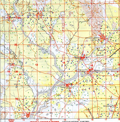
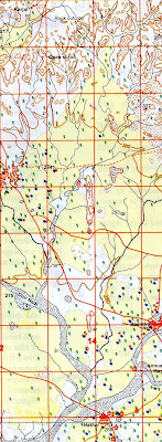
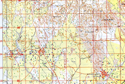
45 D/10; Eastings 10-18, Northings 17-28
(ANSWERS AND EXPLANATION)

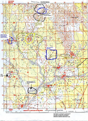
I. Study the map sheet no 45D/10; Eastings 10 to 18, Northings 17-28 and answer the following questions.
a. How does scale of the map affect the area shown by the map?
The ground area shown by a map changes with the change in scale. The area shown decreases in the scale is enlarged . If two maps of the same size are drawn on different scales , the one on a smaller scale will represent more ground area than the one drawn on a large scale.
b. Give four-figure grid references of the following:
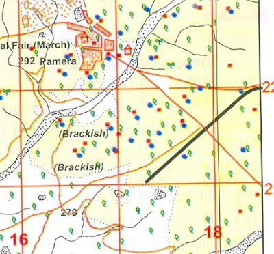
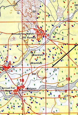
i. Settlement Pamera - 1622
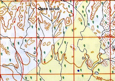
ii. Open Scrup in the north - 1326
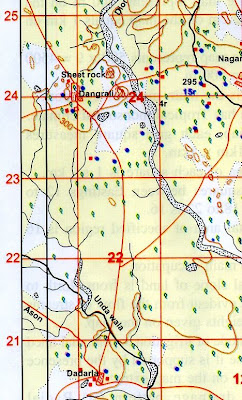
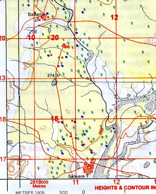
iii. Sheet rock north of Dangrali - 1024
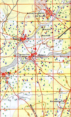
iv. Brackish south of Pamera - 1621

c. Give six figure grid references of the following:
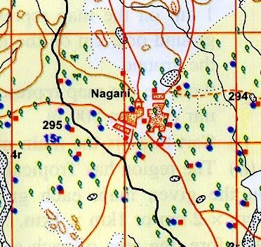
i. Temple at Nagani - 121244
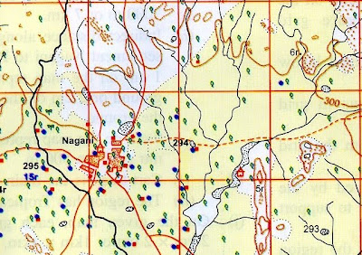
ii. Perennial lined well at Dadarla - 103207
iii. Dry tank north of Posintra 154212
iv. Spot height 296 south of Dadarla - 098203
d. What are conventional signs and symbols.
These are standard symbols used on a map and explained in the legend to convey a definite meaning.
e. What is the meaning of the following conventional signs?
i. 294 in grid square 1324 - Prominent Surveyed tree 294
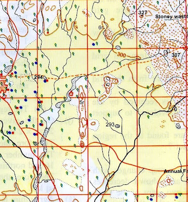
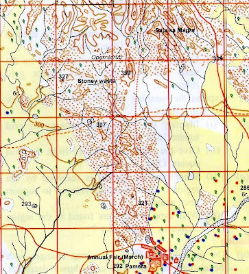
ii. Stony waste in grid square 1525 - these are the fragment rock pieces occurred because of weathering of rocks . These are generally seen in arid or semiarid regions.
iii. Blue dots south of village Malgaon – Perennial lined wells

iv. Rock out crop in grid square 1327 – It is found in open scrub with scanty desert type vegetation where rocks are cropped out.
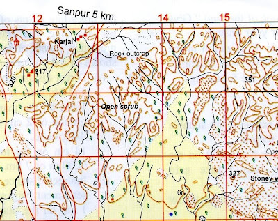
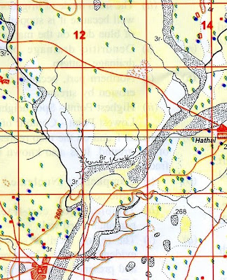
v. 6 r in grid square1218 – The relative height of river bank is 6 metre.
vi. Sheet rock in grid square 1024 – these are well polished hard rocks which are exposed to the surface.

f. Give the directions of the following:
i. Settlement Nagani (1224) from open scrub (1326) - South West
ii. Village Mohabbatgarh (1717) from village Hathai (1418) South east
iii. Village Dadarla (1020) from village Dangrali (1024)- south
iv. Tank with embankment (1018) from village Pamera (1622) - South west
g. What are Eastings and Northings?
Eastings is the distance due east in Longitude from the preceding points of measurement. Northing is the distance due north in latitude from the preceding points of measurement . Both lines are shown in red colour on the map.
h. Find out the distances between the following:
i.Direct distance in kms between settlement Dangrali (1024) and Malgaon (1620)
Direct distance between settlement Dangrali and Malgaon is 14 cm.
1 cm on the map represents 500 m on the ground or 2 cm on the map equals 1000 m on the ground.
14 cm on the map represents 500 X 14= 7000m or 7 km.
ii. Indirect distance in kms along the cart-track from settlement Nagani (1224) to Posintra (1521)
Indirect distance along the cart track from settlement Nagani to Posintra is 9 cm.
1 cm on the map represents 500 m on the ground or 2 cm on the map equals 1000 m on the ground.
9 cm on the map represent 500 X 9 = 4500 mtr or 4km and 500m.
i. i. What is the main mode of transport as shown on the map?
Cart -track is the main mode of transport.
ii. What do you infer about the climate of the region shown by map extract?
The region has Tropical monsoonal climate.
j. Calculate the area in square kms of the region enclosed by Eastings 12to 16 and Northings 18 t0 22.
On the given map, each grid square measures 2cm X 2 cm or 1 km X 1km
Therefore , the area of each square is 1 sq km. the number of squares between Eastings 12 to 16 and northings 18 – 22 is 16
Therefore the total area of specified region is 16 sq km.
k. What is the main occupation of the people living in the area shown in the map extract?
Agriculture is the main occupation. (Yellow wash, perennial wells)
l. i. What is the general slope of the land? Give two reasons to support your answer.
The general slope of land is from North to South. It is evident from the flow of streams and spot heights given on the map.
ii. What is the main mode of irrigation in the region? Justify your answer with example.
The main mode of irrigation is perennial lined well because it is supported by the presence of blue dots on the map extract.
m. Identify the drainage patterns in the following:
i. In grid square 1422 - Dendritic drainage pattern
ii. ii. In grid square 1327 - Radial drainage pattern
n. i. Which part of the map extract is not suitable for agriculture? Give reason.
ii. ii. In grid square 1327 - Radial drainage pattern
n. i. Which part of the map extract is not suitable for agriculture? Give reason.
Northern part because of sloping land and erosion by streams.
ii. Locate the highest and lowest point on the map and also give four figure grid reference.
ii. Locate the highest and lowest point on the map and also give four figure grid reference.
Highest point – spot height 362 (1627)
Lowest point - Contour of 180 m (1517)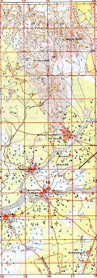
o. Express the meaning of 1:50,000 printed below the map extract.
It means 1 unit on the map represents 50,000 units of the ground . It is also known as Representative Fraction.
p. i. Identify the settlement patterns in grid square 1622 and 1619.
Compact or Nucleated and Dispersed settlement
ii.Give the man-made feature from the grid square 1224.
Temple, huts, cart-track, pack-tracks, perennial lined well.
q. i. What type of rainfall is received by the region? Give suitable evidence to support your answer.
Temple, huts, cart-track, pack-tracks, perennial lined well.
q. i. What type of rainfall is received by the region? Give suitable evidence to support your answer.
The region receives seasonal rainfall, it is evident from the dry river bed, dry tanks and presence of islands in the river.
ii.What type of trees are found in the region by map extract.
Mixed vegetation and plantation palms
Mixed vegetation and plantation palms
7 comments:
thanks alot for uploading answers. i came to know my mistakes and also how to answer exactly to the point.
Thanks for helping me
Thanks for helping me
Thanks for helping me
This site is really helpful.
I appreciate the practical examples that make the concepts clear. free auto clicker should be used responsibly and within the terms of service of respective applications. Vist this article and read more information about it.
Post a Comment